

Sequoia and Kings Canyon National Parks are often discussed as one destination, but they are not one compact park. Together they stretch from hot foothills to giant sequoia groves, deep river canyons and high Sierra trailheads, with long mountain roads linking areas that feel completely different. The reward is extraordinary variety; the planning challenge is that driving time, elevation and seasonal access matter much more than the map suggests.
For a first visit, the strongest plan is usually to spend two or three nights and focus on Giant Forest, Grant Grove and—when Highway 180 is open—the Kings Canyon Scenic Byway. This guide explains how to choose an entrance, where the giant trees are, which roads require extra attention and how to combine the parks with Yosemite or a wider California road trip.
- 1Enter Sequoia early; General Sherman + Congress Trail
- 2Drive to Grant Grove; General Grant Tree
Quick planning: Sequoia & Kings Canyon at a glance
| Question | Best answer for most first trips |
|---|---|
| How long? | 2–3 nights; add more for long hikes or wilderness travel. |
| Best season? | Late spring through early fall for the broadest road access; winter is beautiful but more limited. |
| Car needed? | Yes. Distances are large and public transport does not replace a vehicle for the full park system. |
| Best bases? | Three Rivers for southern Sequoia access; Grant Grove/Wuksachi for in-park convenience. |
| Top first-timer sights? | General Sherman Tree, Congress Trail/Giant Forest, Moro Rock area, General Grant Tree, Kings Canyon viewpoints. |
Understand the geography before booking a hotel
The southern entrance near Three Rivers climbs into Sequoia National Park toward Giant Forest, Lodgepole and Wuksachi. The northern entrance via Highway 180 reaches Grant Grove in Kings Canyon National Park. In snow-free periods the Generals Highway links the two main developed zones, but the drive is winding and much slower than mileage alone suggests.
The dramatic Kings Canyon Scenic Byway continues east from Grant Grove into the canyon toward Cedar Grove when seasonal conditions allow. That road is a destination in itself: expect viewpoints, river scenery and a sense of remoteness very different from the famous sequoia groves.
Giant Forest: General Sherman Tree and the best sequoia walks
Giant Forest contains the park’s most famous tree, the General Sherman Tree, but the forest is more satisfying if you go beyond the photo stop. The Congress Trail and nearby connecting paths let you walk among mature giant sequoias at a slower pace, where scale becomes easier to appreciate than from a parking lot.
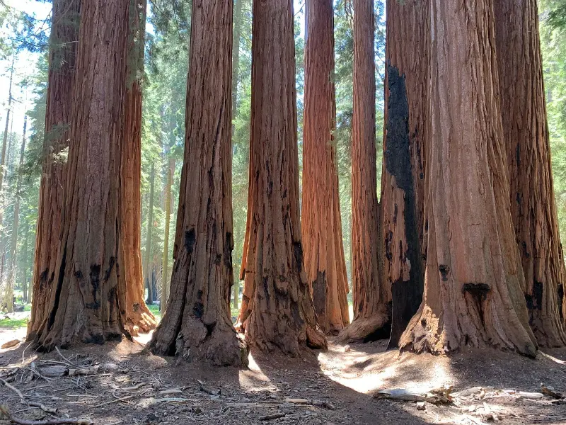
Arrive early on busy summer days. Parking and shuttle patterns can change seasonally, and walking distances between shuttle stops, trailheads and groves can add up. Cooler mornings also make hiking more comfortable and give you better odds of experiencing sections of forest without a constant stream of people.
Moro Rock, Tunnel Log and the high-country feel
The Moro Rock area adds granite views and a very different landscape to a day centered on trees. The stairway to the top is short but steep and exposed; people uncomfortable with heights may prefer nearby viewpoints and forest trails. Tunnel Log is a classic roadside stop, but it should be treated as a quick diversion rather than the reason for visiting this part of the park.
Road access around Crescent Meadow and Moro Rock can be managed differently during peak periods, including shuttle use and traffic controls. Check current NPS information before building a minute-by-minute schedule.
Grant Grove and the General Grant Tree
Grant Grove is the easiest introduction to Kings Canyon National Park and contains the General Grant Tree, one of the world’s largest giant sequoias. The grove works especially well on arrival or departure day because the main loop is manageable and the area sits close to Highway 180.
If you have only one day for both parks, Giant Forest normally deserves priority for the most immersive giant-sequoia experience. If you have two or three days, Grant Grove becomes much more valuable because it pairs naturally with the Kings Canyon Scenic Byway.
Kings Canyon Scenic Byway: why you should not rush it
When open, Highway 180 descends from Grant Grove toward the canyon, passing broad views, forest, river corridors and trail access. The road is curving, scenic and slow. A common mistake is treating Cedar Grove as a simple out-and-back mileage calculation; in practice, viewpoints, road conditions and stops turn it into a substantial day.
The payoff is one of California’s most underrated mountain drives. If Yosemite feels defined by granite walls and waterfalls, Kings Canyon often feels more spacious and less choreographed. Bring food, fuel appropriately before remote sections, and check current road status before leaving the Grant Grove area.
2026 road and campground planning note
The National Park Service reports that nearly all main park roads are open in late summer 2026, but mountain access can change quickly because of fire, storms, snow or repair work. Generals Highway has vehicle-length advisories on tight sections, and NPS specifically warns larger RVs and trailers to review restrictions. There are no gas stations or EV charging stations inside the national parks.
For 2026, NPS also lists Buckeye Flat Campground as closed because of past winter-storm damage and South Fork Campground as closed because of flood and landslide damage. These are exactly the kinds of details that can change between seasons, so verify the official current-conditions page even if you visited recently.
Best hikes for a first visit
- Congress Trail / Giant Forest: the essential walk for a deeper giant-sequoia experience.
- Tokopah Falls: a longer valley-style walk near Lodgepole, best when water levels and weather cooperate.
- Big Trees Trail: an easier loop that works well for families or a lower-effort forest walk.
- General Grant Tree Trail: a short, high-value loop in Grant Grove.
- Mist Falls: a substantial Kings Canyon hike for visitors with more time, fitness and favorable conditions.
Where to stay: Three Rivers, Wuksachi or Grant Grove?
Three Rivers offers the largest cluster of services near the southern entrance and works well if Giant Forest is your priority. The trade-off is the long, winding climb into the park each day. Wuksachi/Lodgepole-area lodging and camping reduce daily driving but require early reservations. Grant Grove is best if you want the northern groves and Kings Canyon road to be central to the itinerary.
Do not book a hotel solely because it looks geographically close. Mountain roads mean that a property outside one entrance may be inconvenient for an attraction near another. Use your first major activity each morning to choose the base.
Compare accommodation: compare hotels and other stays on Booking.com.
A strong 2-day itinerary
| Day | Morning | Afternoon / evening |
|---|---|---|
| 1 | Enter Sequoia early; General Sherman + Congress Trail | Moro Rock/Crescent Meadow area, sunset forest drive |
| 2 | Drive to Grant Grove; General Grant Tree | Kings Canyon Scenic Byway and viewpoints if open |
With a third day, add a longer hike, revisit Giant Forest at a quieter hour or slow the Kings Canyon drive. A third night is especially valuable if you are connecting to Yosemite, because it prevents the transfer day from consuming half of both park visits.
Families, mobility and altitude
Families can have an excellent visit without major hikes. Giant sequoia loops, viewpoints, picnic areas and short walks provide plenty of variety. The bigger issue is driving: children may tire of long mountain roads, so build breaks into the day rather than stacking every viewpoint.
Elevation changes are significant. Some visitors feel short of breath or develop headaches at higher elevations, particularly after arriving directly from the coast or Central Valley. Hydrate, start with gentler walks and do not treat altitude symptoms as something to push through.
How to combine Sequoia & Kings Canyon with Yosemite
The parks combine naturally with Yosemite National Park, but they should not be treated as neighboring entrances. Driving routes around the Sierra can be long, and seasonal high-country roads affect what is practical. On a California road trip, many travelers place Sequoia/Kings Canyon between Los Angeles and Yosemite, then continue toward San Francisco.
For the broader route, use our two-week California road trip and California travel guide.
Official planning resources
- NPS current conditions — roads, trails, fire restrictions and closures.
- NPS road information — Generals Highway, vehicle advisories and seasonal roads.
- NPS plan your visit — camping, hiking, safety and visitor services.
Food, fuel and services inside the parks
Services are limited compared with a city-based trip. Carry water and snacks even if you plan to eat at developed areas, because opening hours can change and driving back to a restaurant may take much longer than expected. Fill the fuel tank before climbing into the parks; the lack of in-park gas is not an abstract warning when mountain detours or roadwork add mileage.
Download maps before arrival. Cell coverage is unreliable in many canyons and forested areas, so navigation, reservation confirmations and emergency numbers should not depend on a live signal.
Common planning mistakes to avoid
The most common mistake is trying to combine too many distant California experiences because they appear on the same state map. Leave buffer time for traffic, weather, parking and spontaneous stops. Reserve only the activities that truly require a fixed time, then protect some unscheduled hours around them.
A second mistake is treating conditions as static. Coastal roads, mountain routes, wildfire restrictions, beach access and attraction operating hours can change. Recheck official sources shortly before travel and again on the morning of any weather-sensitive or road-dependent day.
Wildlife, bears and food storage
Black bears live throughout the Sierra, and food-storage rules are part of visiting responsibly. Never leave scented items visible in a parked vehicle where restrictions prohibit it, and use campground bear boxes or approved storage exactly as instructed. A bear that learns to associate people and cars with food can become dangerous and may ultimately be destroyed; careful storage protects both visitors and wildlife.
Deer and smaller animals are common near roads at dawn and dusk. Drive slowly in low light and never feed wildlife. Even squirrels and jays become aggressive around busy picnic areas when visitors ignore feeding rules.
Photography and the best light
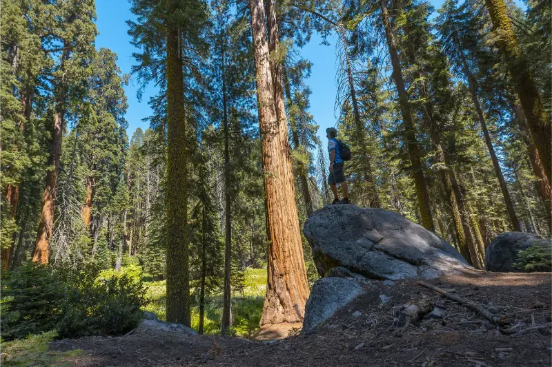
Giant sequoias are difficult to photograph because the trees are enormous, the forest is contrasty and popular groves can be busy. Early morning and late afternoon create softer light and quieter trails. A wide-angle lens helps, but including a person or smaller tree for scale can communicate the size better than trying to fit the entire trunk into the frame.
For mountain views, haze can increase in summer and wildfire smoke can affect visibility. Build photography around the conditions you have rather than driving hours for one predetermined image.
Compare this park directly with Yosemite in our Sequoia vs Yosemite guide.
Looking for the right place to stay? Compare hotels and accommodation on Booking.com.