

Destinations › West › Utah › Canyonlands National Park
Canyonlands is not one park road. It is a huge landscape divided by the Colorado and Green rivers into districts that require separate approaches. Island in the Sky is easiest from Moab, The Needles is farther south, The Maze is remote backcountry and the river corridors form a fourth planning world.
For most first-time visitors, start with Island in the Sky. Add The Needles only if you have another full day and want a more hiking-focused experience. Trying to sample every district in a short trip defeats the scale that makes Canyonlands special.
Canyonlands at a glance
| District | Best for |
| Island in the Sky | First visit, overlooks, short hikes |
| The Needles | Longer hikes and backcountry feel |
| The Maze | Experienced remote backcountry travelers |
| Rivers | Rafting/river expeditions |
| Best base | Moab for Island in the Sky; Monticello/Moab for Needles depending route |
Island in the Sky
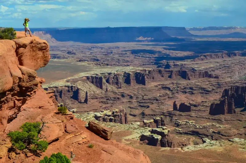
Island in the Sky sits on a high mesa north of Moab and provides the easiest access to vast canyon views. Mesa Arch, Green River Overlook, Grand View Point and Upheaval Dome can fill a day when you include short hikes rather than merely driving between pullouts.
Mesa Arch
Mesa Arch is famous at sunrise because light can illuminate the underside of the arch, but the scene is crowded and not necessary for a rewarding visit. Midmorning or evening offers a calmer experience and still reveals the dramatic canyon drop behind the arch.
Grand View Point
Grand View Point is one of the clearest places to understand the park’s scale. The viewpoint itself is easy to reach, and the rim trail extends the experience without committing to a major descent.
Upheaval Dome
Upheaval Dome adds a different geological story and a moderate hike. It is useful when you want more walking than a viewpoint tour but do not have time for a backcountry route.
The Needles
The Needles district is reached via Utah 211 and sits far from Island in the Sky by road. It is known for sandstone spires, longer hikes and a stronger sense of backcountry immersion. Chesler Park is a classic objective, but it requires real time, water and route planning.
As of late August 2026, NPS lists front-country roads in The Needles as open after earlier summer fire-related closures. Conditions can change rapidly, so verify current status before driving from Moab or Monticello.
The Maze
The Maze is one of the most remote areas in the national-park system. Reaching it can require high-clearance four-wheel-drive travel, route-finding and self-reliance. It is not a day-trip alternative when Island in the Sky is crowded.
White Rim Road
The White Rim Road forms a backcountry loop below Island in the Sky and requires permits for motorized and overnight use. It demands an appropriate high-clearance 4WD vehicle, extra fuel and water, tire repair equipment and current road information.
NPS warns that backcountry towing can cost more than $1,000. That is a useful reminder that vehicle capability and self-recovery planning are not optional details.
Road conditions in 2026
NPS road updates from August 24, 2026 list Island in the Sky Scenic Drive and Shafer Trail as open, with White Rim permits still required. The Needles front-country roads are also listed open, while several backcountry roads require high-clearance 4WD and can change after storms.
One-day first visit
From Moab, spend the day at Island in the Sky: Mesa Arch, one longer rim walk, Grand View Point, Green River Overlook and optional Dead Horse Point at sunset. This gives you variety without spending the day in the car.
Two-day Canyonlands plan
Use day one for Island in the Sky and Dead Horse Point. Use day two for The Needles if you want a longer hike, or for a guided river/4WD experience if backcountry logistics are unfamiliar.
When to visit
Spring and fall are best for hiking. Summer is very hot with limited shade, while winter can bring snow and icy roads at higher elevations. Thunderstorms can quickly change dirt-road conditions, especially in backcountry areas.
Canyonlands mistakes to avoid
- Assuming Island in the Sky and The Needles connect inside the park.
- Driving Shafer/White Rim because photos make it look easy.
- Starting a long Needles hike without enough water.
- Using Moab as the only fuel/water plan for remote backcountry travel.
- Rushing every overlook instead of walking one rim trail slowly.
Official resources
Continue planning your Utah trip
- Utah Travel Guide
- Best Things to Do in Utah
- Utah Road Trip: Mighty 5
- Best Places to Visit in Utah
- Best Time to Visit Utah
- Where to Stay in Utah
- Zion National Park Travel Guide
- Bryce Canyon National Park Travel Guide
- Arches National Park Travel Guide
- Moab Travel Guide
- Canyonlands National Park Travel Guide
Navigation and offline preparation
Cell service is unreliable in much of Canyonlands. Download maps before leaving Moab, carry a paper map for remote travel and tell someone your route if you enter the backcountry. A phone without service is not a navigation plan by itself.
Frequently asked questions
Which district is best for a first visit?
Island in the Sky because it is closest to Moab and combines overlooks with short hikes.
Can I drive between districts inside the park?
No. The rivers divide the districts, and road travel between them requires long outside routes.
Do I need 4WD?
Not for paved Island in the Sky or Needles front-country roads, but many backcountry roads require high-clearance 4WD and permits.
Final planning checklist
- Check official park conditions 24–48 hours before major hikes.
- Download offline maps before leaving gateway towns.
- Carry water, sun protection and a warm layer even when the forecast looks simple.
- Keep one activity per day flexible for parking, storms or heat.
- Avoid scheduling a long drive immediately after a demanding sunset hike.
A deeper planning strategy
Canyonlands planning improves dramatically when you decide which district matters before leaving Moab. Island in the Sky is a viewpoint-and-short-hike day. The Needles is a hiking day with a longer approach. White Rim is a backcountry logistics project. The Maze is an expedition-level objective for experienced travelers. Those are different trips, not variations of the same afternoon. First-time visitors should resist the idea that seeing more districts automatically means seeing more of Canyonlands. Spending several hours walking a rim or exploring one Needles route gives a much stronger sense of the park’s scale than collecting entrance signs. The geography itself is the lesson: rivers divide the landscape, roads take time, and remoteness is part of the experience.
Where to stay for each district
Compare available accommodation for your dates, budget and preferred location before you finalize your route.
Moab is the natural base for Island in the Sky. For The Needles, Moab is still workable, but Monticello can reduce driving depending on your next destination. The Maze generally requires a backcountry itinerary rather than ordinary hotel-based sightseeing.
Do not choose lodging by the park name alone. “Canyonlands National Park” covers a huge area, and the entrance you need may be more than an hour from the hotel that looked close on a booking map.
Compare accommodation: compare hotels and other stays on Booking.com.
Shafer Trail and scenic dirt roads
Shafer Trail drops dramatically from Island in the Sky toward the White Rim area. It may be open to appropriate vehicles, but conditions can change after storms. Height, clearance, tire condition and driver confidence all matter.
If you are unsure, enjoy the road from viewpoints above or book a guided 4WD trip. The purpose is to experience the landscape, not prove that a rental vehicle can survive a road it was not designed to drive.
The Needles for hikers
The Needles is one of Utah’s best districts for hikers who want a deeper day away from roadside viewpoints. Chesler Park, Joint Trail and Elephant Canyon routes require more planning than Island in the Sky because distances, heat and navigation become more important.
Start early, carry a paper or offline map and verify water expectations. The red-and-white spires become more impressive as you walk among them, which is why a full Needles day can be more rewarding than trying to visit two districts.
River and photography experiences
The Colorado and Green rivers define Canyonlands. Multi-day rafting trips through Cataract Canyon create a completely different perspective from the mesa tops, while calmer river sections near Moab can be sampled on shorter trips.
For photographers, sunrise at Mesa Arch is famous but crowded. Grand View Point, Green River Overlook and late-day rim walks offer equally powerful layers without requiring a pre-dawn race for tripod space.
Permits and backcountry planning
Front-country sightseeing does not require the same planning as White Rim, river or overnight backcountry travel. Once you leave paved roads or developed trail systems, permit rules, vehicle capability and emergency planning become part of the trip. Check the exact district and activity on the NPS site because a permit that applies in one area does not automatically cover another.
For first-time backcountry visitors, guided 4WD or river trips can be a smart way to experience the interior without turning vacation into a self-rescue exercise. Canyonlands is a place where conservative planning usually expands what you can enjoy rather than limiting it.
Connect Canyonlands with the wider Moab region
Canyonlands is easier to plan when it is grouped with Moab activities and the Monument Valley corridor.